www.voria.gr
The next 10 days will see the first results of the geophysical survey conducted on the Kasta Hill in Amphipolis by the Geophysics Laboratory of the Geology School at the Aristotle University of Thessaloniki. The research is led by Prof. Grigorios Tsokas, Head of the Geology School.
As reported by Voria.gr, a scientific group from the Aristotle University of Thessaloniki has been trying to find remains of buildings, and thus provide new directions to the archaeological excavation team. The first results will be presented to the media up until 15 December.
Sources from the archaeological team have qualified the initial evidence of architectural traces inside the mound as ‘positive’. In an interview for Voria.gr, they maintained that most of the measurements were probing into spots in the vicinity of the already discovered chambers at a depth of about 4-5 m.
The first results of the Geophysics Laboratory work however will not be limited to the closest areas of the funeral compound, but will cover the remaining unstudied areas of the mound as well. Its whole surface spans two hectares, i.e. it is too big to be covered by the archaeologists.
As sources mentioned, extended research has been carried out outside the Kasta Hill – in the area by the tomb's entrance. The observations promise interesting data. Using other variables, but the same method of electrical tomography, researchers have been probing into depths of dozens of metres.
The investigation results are extensively studied and evaluated, and then verified again by the Geophysics Laboratory in Thessaloniki prior to presenting a final report upon completion of the works.

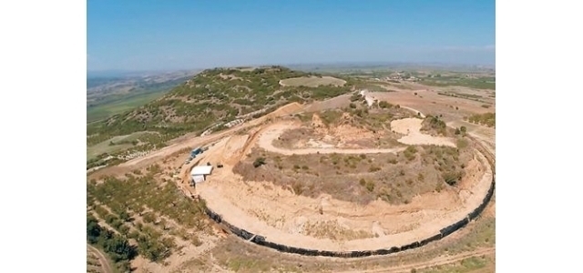
A seismic tomography image of the Kasta Hill by the group of scientists Polymenakos-Papamarinopoulos-Liosis-Kukulis, 1998
The conclusions, which the geophysicists will reach, based on the three-dimensional tomography image of the Kasta Hill, will provide guidance for the further work of the archaeological team. The latter however won't take place before spring time as adverse weather will discourage further digs earlier than that.
But rainy weather is not a matter of concern for the Geophysics Laboratory. Three-dimensional images of the hill can still be created without delay despite constant showers.
What is tomography?
This is a method whereby geophysicists ‘infuse’ electricity into the ground and measure the distribution of resistance at places suspected of hiding an archaeological site. By using a special algorithm, scientists produce images of underground spaces: either in sectors, i.e. in two dimensions, or by mapping out the whole space three-dimensionally.
Apart from the opportunity for three-dimensional imaging of archaeological underground spaces, this method offers the advantage of limitless penetration and ‘vision’ into the depths, which means it is ideally suited for sizeable underground finds.
Electrical tomography has been successfully applied at important archaeological sites such as Vergina, the south wall of the Acropolis in Athens, Pydna, Thessaloniki’s medieval walls, the tomb of Messinos, Pella and Apollonia, where a three-dimensional image of the tomb was created.
Geophysical testing is a method, which has been recognised by most archaeologists and applied at numerous archaeological excavations.


