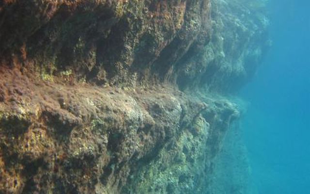
A submerged coast on Anafi island, the Cyclades. Photos: ethnos.gr
A lot of Greek coastal areas submerge whereas others rise, as shown by the geological and geomorphologic survey and mapping conducted by Associate Professor Niki Evelpidou from the Department of Geology and Environment of Athens University.
For example, a series of sudden submergences of about 3 metres was observed in the Cycladic islands, the latest one being due to the earthquake on Amorgos island in 1956. Assoc. Prof. Evelpidou describes that fact in her work, which has been recently awarded by the Academy of Athens as a "work through which the geological knowledge of Greek lands evolves." An earthquake that happened 3,300 years ago and destroyed the houses in the Neolithic settlement on Naxos island caused the deepest subsidence of the Cycladic coastline.
"The seven cases of coastline subsidence that we mapped on the Cycladic islands were a real surprise to us. Most of them had such geomorphic features that testified to their abrupt co-seismic submergence. I travelled around the entire Cycladic coastline and dived where we had to map all the former coasts that can remain petrified only in carbonate rocks", Assoc. Prof. Niki Evelpidou told "Ethnos" newspaper.
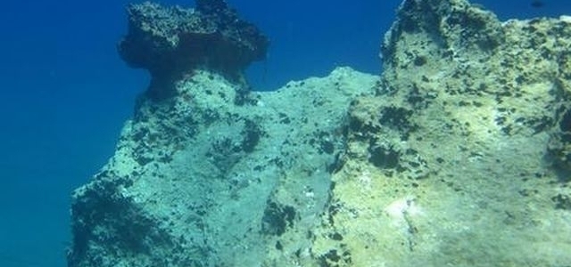
Diving in Amorgos
The methodology used by the specialist indirectly calculates when the water level remained stable (a prerequisite for the creation of the geological form in question) and interprets the processes that occurred, for example, whether the submergence was gradual or due to a sudden tectonic event.
"Signs of coastline subsidence are detected only where the rock is not divided into many layers and the biological erosion is favourable. Ancient coasts were identified by submerged tidal notches", emphasizes Assoc. Prof. Evelpidou.
The Sporades islands also suffered repeated subsidence, often along with earthquakes, although each island had its own development (6 cases of subsidence were detected along the coast of Skopelos island, 7 on Alonissos island, 2 on Skyros island). "The marks of the former water level have "petrified" in the steepest part of the coast. The rapid subsidence has left these very clear traces intact, giving us the chance to discover the geological history of the area."
At the opposite end of the Cycladic islands and the Sporades that have submerged in the recent past, is the Ionian Sea where there is tectonic elevation and subsidence. In Kefalonia in particular "the earthquake in 1953 (with a magnitude of 7.2 on the Richter scale) elevated the southeast part of the island by 50 cm, from Karavomilo to Skala. However, in the most northern part of Kefalonia, on the Erissos peninsula that has not been affected by recent earthquakes, there are traces of tectonic subsidence."
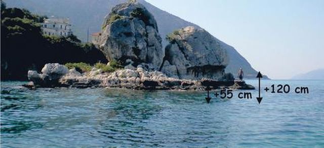
A photo of the elevated coast in Kefalonia. Its highest part reaches 120 cm and its lowest has risen by 55 cm.
Ithaca also submerged before the 19th century, at rates ranging from 0.25-1.25 mm/year.
Attica has elevated twice. However, traces of recent subsidence were found in the area as well. The researcher dated these tectonic events with the use of radiocarbon (14C) and the results of her study are going to be published in an international scientific journal.
There were also clear traces of subsidence in the northwestern part of Evoikos bay near Malesina along at least 22 km of the coastline. According to Assoc. Prof. Evelpidou it was due to the earthquake in 1894 that caused a tsunami that, in turn, was dated with the help of organisms found on boulders washed ashore.
"On the other side of Evoikos bay, Evia seems to have risen by up to 4 metres. We were lucky we found fossils of biological organisms on the two elevated coastlines, which today are 1.7 metres and 3.8 metres respectively above the present sea level. We used radiocarbon to date them so we can be sure that these elevations occurred in 360 BC and 4795 BC," says the specialist.
"Research works never stop", she adds. Assoc. Prof. Niki Evelpidou conducts her research in the winter and summer and knows very well both the seabed of Greece and how to explore it.
After October her research interest will turn to the coastline from Samos island to Kos island, which is quite long, and it will take her at least two years to study it and map it. Meanwhile the results of her research on Kassos island and Karpathos are in the press. There the tectonic activity had changed and the continuous elevations had turned into a continuous subsidence that the researcher measured and mapped in 2013.
What do all these phenomena mean for us?
"We understand the trends in a specific area in the first place. To see the future we must know and understand the past," says Assoc. Prof. Niki Evelpidou, interpreting the phenomena of coastline subsidence and elevation.
"On the other hand, when a region submerges part of land is lost that can be equal to many square metres of coastal zone. In these cases the coastline that is so valuable for a country like Greece is threatened by subsidence and the part that remains on land becomes more susceptible to phenomena such as sea erosion. Conversely, when an area elevates, new parts of land appear that previously were under water," explains the specialist.


